Thursday, August 30, 2012

4:45pm

What a day!  First day to get out to the area and survey the damage (hence the long time between updates) and it's a mixed bag of tricks out there.  My first issue: leaving my parking garage.  What a mess, that place ended up with people parking where ever they could and the negotiation of getting out became a practice in spatial relations and guts. 

Day started off driving north and east along I-10 to I-12 since most roads to the west were closed due to standing water and the Lake Pontchartrain Causeway was closed as well so the long way I went.  The "twin spans" over the Eastern side of the lake and there was a lot of debris that had been pushed off to the side of the road. I saw a lot of seaweed and wood (that I later learned was crab traps).

Saw some serious flooding from the road way in Slidell, say a shrimp/fishing boat that was half in a tree, half in the water.  I also saw trucks, cars and people floating by them on small fishing boats.  It's a tragic scene really, but you can't help but be awed by the sheer magnitude of it all. 

The North Shore was in decent shape, most grocery stores were open though only partially (no fresh foods, frozen or cold foods though pallets of ice were at the exits and you show your receipt to the man by the pallets and he hands you the number of bags you've paid for.

The New Orleans area is doing well for the most part.  It's all dry and not much standing water from what I saw.  There is still minimal electricity (900,000 homes without power statewide) and non-working traffic lights which is leading to a lot of people running their cars through intersections with reckless abandon and the number of times either myself or other cars avoided being broadsided is high.

Most neighborhoods I went through today had streets filled with tree limbs that weren't very large but there was a TON of leaves everywhere and they are clogging the drains and piling up in the streets.  Driving down streets with this issue is like driving on ice.

Lots of convoys around the city of electrical company trucks.  Largest one I saw was 13 trucks heading into the Metairie area and, reportedly, they are being cheered as they enter neighborhoods.  Apparently this is just the first wave, the next wave from out of state is expected tonight.

So the curfew has been lifted here in New Orleans, you think that has something to do with the Saint's playing tonight in Nashville?

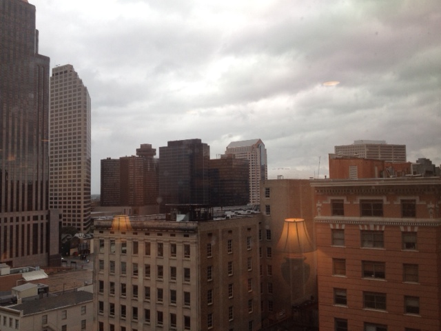
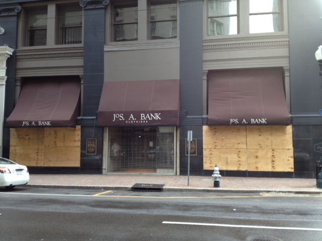
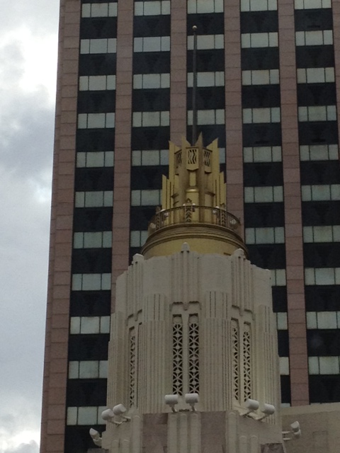
Some pictures below from the day out as well as what the edge of one the remaining feeder bands looks like as it enters the downtown area. 


Wednesday, August 29, 2012

6:00 pm

The rain continues as well as the wind.  For most of the day I've watched this billboard in the weather and well, not such good news to report for it.  In this picture,taken this morning around 10:00am you can see it's still intact, giving a little in the winds but still intact.

And just this was taken around 4:00pm
This was taken just about 5:30pm.
Bless it's heart, it never had a chance.

Interesting facts about the power of this storm.  On 8/28 the hurricane caused the Mississippi River to flow backwards 182,000 cubic feet per second and raised the river 10ft above it's normal level for this time of year.  That's a lot of water being moved in the opposite direction on the world's 5th largest river.

The airport is closed for another day, but it's opening is in doubt for at least a week, maybe longer.

The winds are still a sustained 30-35 mph with gusts in the 40 mph range.  The intrepid weather watchers are saying the wind will die off tonight to below 30 mph but I'm not holding my breath on that one.

Trees trees trees.  It seems that most of the damage in the area is confined to the arbor variety in the historic areas of the city.  Most pictures I've seen show the whole root ball being taken up right out of the ground so we are looking at 10-15 ft (diameter) root balls in the air with large trees laying across power lines and road ways.

There is one of those large construction cranes directly in-front of my hotel room, 3 blocks away.  I've notice it moving a lot lately and now the top portion has moved out from the position it was in this morning.  Something to watch tonight.

One last thing, since today is the 7th anniversry to the day of Katrina's land fall, the news did a nice graphic comparison of the two storms' path into the state. 
Compared to Katrina, Issac is a bit indecisive, no?


1:15pm

Decided during a lull in the storm I'd ventured out to the to see what was out there and I'll post those photos below.

Lots of heartbreak out coming out about people losing everything, including pets, when the flooding began down south.  Common theme in everyone's dialogue: "We didn't think it would be that bad, it's only a Category 1."  Well, heed this warning for the future, if you're in an area that evacuations are recommended: leave.  Regardless of storm strength, it can do bad things very quickly. 

Per the Sheriff of Jefferson Parish, this morning they had a rise of water of 1.5 feet in 30 minutes.  This is concentrated in the southern portion of the Parish where most of the flooding has been happening today.

Ladies and gentlemen, Vic Mackey is now the Mayor of New Orleans.


New Orleans now has a curfew.  I guess Mom and Dad got mad.

Per the New Orleans' Mayor, several fires happened last night, most 1 alarm, one suspicious in nature.  Also the District Attorney is telling us that he is still working and prosecuting through the store.  The biggest issue he is facing: no electricity so they are unable to pull complete criminal histories so all offenders are being treated as violent when they are brought it.  Also the looting statute ups the normal sentence to a minimal mandatory 3 years.  Ouch.  Law and Order: New Orleans the next stop in the series?

Lots of video of uprooted trees coming in, most are laying in the middle of the street and maybe on cars, none so far on homes.

20 streets in New Orleans are flooding, they won't say which ones but they expect the pumps to have them cleared soon.

I saw this fall from my hotel room (the new one) this morning.  It made quite a boom when it fell.  


11:45 am

I've moved!  Well, it's not really that exciting, but I have moved rooms.  The reason is leakage.  No not me, the room.  Apparently my old room was the only room that did not have a room above it, just a gravel roof that started to leak during the night.  Now, luckily the water didn't start coming into the room till early this morning.  Photos below of the multipule water sources.


All these, besides the window, were right over or right behind the bed.  Oh what a wake up call that would have been.  Lucky for me I've been up since 2 am thanks to 95 mph gusts.

Plaquemines Parish is under mandatory evacuation now.  Levees are failing in multipule locations and it's time to get those people out, no reason to risk their lives nor the emergency workers who would have to rescue them.

Is it just me or is there something reassuringly funny to hear the Mayor of New Orleans call people knuckle-heads?  And they say politicians are dull.

My new room has a better view of downtown and I can see a good portion of Poydras, one the major roads that goes through downtown, and passes right in-front of the Superdome, City Hall and all the of the skyscrapers in the city.  I see minimal traffic on the road, mainly National Guard Humvees and police cars running code 1 (lights only, no siren). 

This morning I've watched the winds shift twice with such ease, it is frightening.  It's almost as if someone adjusted the fan to a different direction and a few hours later, switched it back. 

Now that there is daylight, I can see some minor damage downtown.  Mainly debris blown in from who knows where litters the curbs of the street and the air.  There is this weird ash like substance that is circulating around the hotel I'm in.  It looks a lot like snow and behaves like it as well; I can't figure out what it's origin is but must be something near by, perhaps the old Hibernia Bank building that is under construction next door. 

The eye of the storm is moving towards New Orleans as of this time.  Don't set that in stone though, this storm is acting so oddly that it is hard to say what move is next. 

A few reports that have been confirmed that there are several different homes that have collapsed in New Orleans.  Also reports of trees in the Uptown area are uprooted and laying across the road and taking out power lines.  Some of these trees are nearly 100 year old oaks that are a large tourist attractions.  No reports of homes beng hit. 


http://www.fox8live.com/story/19368931/despite-warnings-house-collapses-on-another-in-gentilly?autoStart=true&topVideoCatNo=default&clipId=7651928


4:45am

Not sure why my updates are out of sync right now.  I'll see what I can do to fix it later today.

Storm is now officially ashore.  There is word about levee topping south of the city, outside the Federal levee system.  If the flooding is bad, look for this to become a hot button issue in the near future once recovery begins.

Storm's pressure is rising, which is good.  The 4:00a hurricane update had the pressure raising 3 milli-bars which is good per the intrepid weather men but the real lack of movement is what is bothering people the most.

The worst part of the storm is hitting New Orleans right now.  It sounds like the monster from Cloverfield is outside my hotel window.  I hope it's the wind whipping around the buildings but you never know.

All billboards that I can see at the entrance to the Quarter are still up and intact though, in other areas of the city, there are shots of billboards that have been ripped to shreds and now flap carelessly in the wind.  There is no damage to the metal structure, but the advertisement is history.

If you ever watched "Swamp People" on the Discovery Channel, that area is getting it bad.  Most of Southern Louisiana is taking it on the chin since the eye is right on top of it and watching transformers blow is quickly becoming the reporters, who are in the area, new time killing venture. 

I was messing with the flashlight the hotel gave me, it doesn't work.  Glad I brought my own. 

So apparently tropical storms are tall enough storms to create lighting.  Guess that explains my lack of lighting and thunder experience.  Most storms need to be in the 40,000 feet in height to create lighting and most tropical systems, for the most part, are around 30,000 feet.  Sometimes there can be tall clouds at the center of the storm that may produce some lighting and thunder but usually, it isn't common.


Tuesday, August 28, 2012

9:00pm

Power is still on here at the hotel but the staff is ready to clear out.  I was down in the lobby earlier with some other insurance people (mainly independent adjusters) and watched the hotel staff clear out the pantry in a hurry.  I honestly think they are abandoning the building for the night, leaving us residents to fend for ourselves.  Glad I have two locks on my door tonight.

You know the news is running out of stories when they start replaying the stories from this morning and acting like they are going on right now.

Rain is pretty much non-stop now as well as the wind.  Earlier I ventured down to the street level between rain bands to get an idea of the wind.  I had to walk down to the corner to actually get a feel for the wind due to the high buildings.  It wasn't bad, the worst I saw was a small tree branch move down the street.

The storm seems to be hanging off shore and not moving.  This is not good for rain reasons, unless this storm starts moving, it's going to drench the lower portion of this state to the point of beyond saturation and create a lot of storm surge in one area.  Per our intrepid weather man, there isn't anything to move this storm either back out to the gulf or push it inland.

A quick look out my window to the left and to the French Quarter shows almost all the neon signs are still up and doing well, only one letter is out but I'm not sure if it wasn't already out before the storm.  A look out towards the river bridge and Harrah's and Lowes show power still on there as well and all the residential and office buildings in-between. 

One thing I've noticed is there hasn't been any lightning.  I've seen more lighting on the TV's backdrop then I have outside.  I've heard some thunder but nothing major. 

Per the news, the worst is yet to come but they've been pushing this ominous prediction back every hour or so.  In preperation (and following hotel guidlines) I've filled my bathtub with water, plus every glass and coffee mug in my room plus a full ice bucket on top of the other couple gallons of bottle water I have.  I really doubt I'll need any of these things but better safe then sorry.


10:30pm

Rain continues outside and the wind is picking up.  Last note had the wind at 61 mph sustained at the airport.  The storm keeps moving to the west northwest and bouncing along the coast line.  New Orleans has been spared the majority of the bad weather, but the night is still young.

Hotel is shut down, we are confinied to our floors for the most part though the stairwells are available if we want to use them.  Watch how fast I move.

Switched news channels.  The constant negativeness of the first channel was getting tiresome.  Dropped one down to a rivial station where they are actually smiling, cracking jokes and giving positive news.  Might be fluff might not be, but hey, it's something different.

280,000+ without power in the state right now.  Every time they show the map of New Orleans and where is without power and where there is, my little area is still green.  Maybe I should rent myself out as good luck for areas.

Curfew is in effect everywhere but New Orleans, the new news station is really enjoying going downtown to Canal street to all the people that are hanging out in the hotel parking areas (they are covered) and watching a billboard get torn apart.

Issac from space isn't that interesting.  I usually like space weather shots, but this is really a oh hum image.

The ground is overly saturated from almost daily rain for 6 weeks and flooding is really becoming a concern for the areas below New Orleans.  Tonight will be a tell-tale time period with the track of the storm and what happens.  Right now, it appears the worst thing New Orleans will have is some minor wind damage and power outages. 


7:00p

Al Roker is here?  What the...? I thought this was a weather event, not a PR stunt.  Ugh.  Yeah no real respect for the man, he isn't really a weather man yet he works for The Weather Channel (What happened at the Today show? Did he out grow Wilard Scott's Ronald McDonald shadow?) and he is here in The Crescent City.  Maybe that's why Issac is taking aim at New Orleans...

I spent about 15 minutes in the lobby watching The Weather Channel and, oy vey, are they a bunch of drama princesses.  You'd think there was a black hole forming at the mouth of the Mississippi the way they play the dramatic music, quick cuts, and sweeping studio camera angles.  Somewhere, Micheal Bay is rubbing his hands greedily looking for slow motion explosion. 

In Texas, they seem to find the trailer park resident to interview after bad storm damage, here in Louisiana, the local news grabs a "Swamp People" reject.  Watching the local news trying to communicate with this guy right now is probably the funniest thing I've watched all day.  He is doing his best but watching the news anchors trying to talk on his level is hilarious because they are tripping all over themselves.

The wind is still a beast here in the hotel.  Every few minutes there is a gust that sounds like a thunder clap in the distance but when I look out the window the palm trees on street level are nearly still.  I can see one of the bends in the river from my room and it's gone from mirror like to full of white caps and swells. 

I have to say, the updates done to this city's pumping stations and levees is impressive.  About 15 minutes ago they closed the last of the three major canals in the city and started the pumps.  One thing to keep note is they want water in the canals to help them maintain structural integrity.  Never thought about that but it makes total sense when you think about the physics of it.

 The camera on the North shore of Lake Pontchartrain is a blast to watch with a certain weather guy.  (Yes, he is the same one who was obsessed with eye of the storm earlier).  There is one lone soul out there watching the lake come ashore.  Our intrepid weather man railed on the green screen earlier trying to tell the guy that he is playing with his life; I guess he got a talkin' to since then because they just showed the same shot and that guy was still there and our weather man was visibly upset by it but said nothing.  

Per the radar, the big yellow red dot on the TITAN radar is showing right on the doorstep of New Orleans.  This might be the one that knocks out the power but we will wait and see.  
6:30pm


New post coming soon, first a little humor.


http://comedians.jokes.com/lewis-black/videos/lewis-black---the-weather
6:00p

Is there an eye, is there not an eye?  That seems to be one particular meteorologists observation in the past few minutes.  Also the storm is taking a stair step approach towards the land which is unusual.  Wind speed at the NOLA airport are 31 sustained wind speeds while here in downtown the rain comes and goes with less time in-between the showers.

Curfews are being announced all over the area.  Haven't seen a New Orleans one yet but I'm sure it's out there.  Most seem to be dawn to dusk while others give concrete times of 8pm to 6am, here in New Orleans, that is usually considered drinking hours. 

Storms forward speed hasn't slowed which is good.  The rain fall total is now given as either 10-15'' or 20'', depending on the speed of the storm. 

Plaquemines Parish will be where land fall will most likely happen.  They've lost roofs on business so far in Venice, LA.   Storm surges are around 4-6' and winds around 45 mph sustained.  Not a pretty picture there.  They have a TV truck there but the weather is preventing the digital signal from coming through.

Military style barricades have been errected along some main roads outside the city to keep people off some lower lying roads.  Also, one of the most interesting laws I've heard in a while: no wake laws for motor vehicles.  The local law enforcements have the right to remove you from the scene if you are caught going more than 5 mph in standing water.  Not sure what the depth requirement for standing water is but I'm sure it is subjective.

There is around 63,000 without power right now state wide.  Here in New Orleans it is still spotty at best but it is growing. Most seem to be in the Uptown/Garden District area of New Orleans which is the historic area of the city and is the location of Tulane, Xavier and some of the most recognizable homes.  It's also home to some massive trees and some of the worst streets I've ever driven. 
4:00pm

So Issac is very close to land fall but nothing here other than rain and more rain though it comes in waves. First major bands are hitting right now and the rain looks like dust moving through the city's canyons.  Heard the first clap of thunder a few moments ago, but really, the wind gusts sound more like thunder than the thunder does.

Tomorrow, 8/28, is the 7th anniversary of Katrina making land fall.  That has a lot of people nervous.  For a lack of better explanation, there is a large portion of the population of the Southern Louisiana that are superstitious and the timing of both of these storms is enough to rattle some nerves and now that the storm is starting to hit New Orleans, they are revisiting some sights that became infamous in Katrina and that can't be good for a lot of people to relive those memories at this time.  

Again, more news about how great the great wall is in Eastern New Orleans.  I admit it's impressive but it seems like they are "spiking the football" before they have a reason too.  First power outage has been reported here in New Orleans, though it is an isloated area and not very big.

All gaming areas are closed in Southern Louisiana and Mississippi so there goes my shelter of last resort if I get too bored. 

And as quickly as the rain and wind came, it is now gone.  About 10 minutes is the maximum that these storms seem to last.  If this storm keeps moving at it's current pace, it shouldn't be too bad but again, if this bad boy sits on top of the area, then it won't be good.

Grand Isle is getting the majority of the TV coverage.  Right now they are getting 50-60 mph winds from the north and they are expecting 6-12 ft tidal surge and heavy rain on Wednesday morning.

I found a pizza place that was open and delivering so I have food for the next few days (though I may tire of pizza by this time Wednesday or Thursday).  The hotel came by earlier and gave me a flashlight and instructions and updates which include:
 - Fill my bathtub with water.  Doesn't say what for, but says to do that.  Way to give directions fellas.
 - The Pantry, which is like a walk-in wet bar/snack bar in the lobby, will be closed tonight at 10pm, if you don't get anything before then, you're doomed to drink bathtub water and eat whatever you can find.
- The building is being locked down at 10pm and there is not unlock date.  Are we being quarantined? 

One thing that is worth noting: There has been a line of dry air being sucked into the hurricane which seems to be making it lopsided and, hopefully, weakened enough that once it hit's land fall, fall apart.  No one knows for sure what it will do but this is a nice little ray of hope to hold onto. 

Posting photos from the lobby area, again, just looks like a stormy day here in New Orleans. 


12:30p:

Issac is now a category 1 hurricane.  One tornado warning issued for Orleans Parish though these are not your typical tornadoes.  Most twisters that people think of are like those monsters that hit Tuscaloosa but these are apparently very small, thin ones that drop down and are down on the ground for a few seconds at the most.  Interesting. 

The storm is slow moving, and the threat of flooding is increasing.  Right now, they are predicting upto 20 inches of rain in the next 24 to 36 hour range.  

Best TV this morning was the complaining done by a council member of a Jefferson Parish (I think) about the quality of work done by a contractor on some of the barriers for flooding in the Parish.  The news anchors did their best to get him to talk about preparations being done but he just rambled on for a solid 3 minutes or so about how poor the workmanship is and, really, I can't blame him (especially is half of what he said was true).

Noticed a few fly-bys of Blackhawk helicopters around the Mississippi River.  Heard a lot of police or emergency sierns earlier but it's been quiet for about an hour now.  When I was in CVS this morning, there was an officer in there buying two cases of water.  Looks like he, along with others, are in here for the long haul.

Per my hotel, the back up generator will last 30 minutes.  After that, who knows what is next.

Learned about the "stadium effect" which means that as the sun rises in the East, the shadow of the taller eye wall clouds cast shadows like into the eye, similar to a stadium.  A nice little factoid to store for Trivial Pursuit.

Going to post photos of the great surge barrier in Lake Bornge that protects eastern New Orleans from a storm surge.  This thing is almost a mile in length, is 26 feet high and this is it's first real test.  The closing of the this barrier is a big deal.  Also I'll post pics of pumping stations here in New Orleans since I'm sure a lot of people will be talking about those soon. 

I'll be back with more updates soon. 


Hello all and welcome.  Let me tell you a story about a tropical storm named Issac, who, as I type, is about 2 hours off the Southeastern shore of Louisiana and bearing down on the Gulf Coast.  I am stationed in downtown New Orleans to provide inital ground reports for my company.  Before I start more current updates, let me discusss the past 24 hours and set the stage for the rest of this week.

I left my home in Fort Worth, TX around 1pm on 8/27 after spending the morning getting things set for my home and dogs.  The drive out was pretty uneventful till I got around Tyler in East Texas when heavy down pours from isloated storms slowed down my drive and added time to the already long (8 hours) drive. After hitting around three of these storms all the way to the Louisiana border, I entered Shreveport around 4:45p and booked it South towards New Orleans.

For anyone who has ever driven to Southern Louisiana from the North, you take I-49 South to I-10 and you know that there are very many isolated pockets of civilization that usually consist of truck stops with casinos and then nothing but open land or swamp lands.  The traffic on I-49 is never heavy and this trip was no different though there was noticeable addition to the usual vehicular traffic: National Guard convoys.  I personally counted 7 convoys on the drive into New Orleans, most of which were between 10 -15 vehicles each including Humvee, Potable (drinkable) water trucks, and fuel trucks.

I reached Baton Rouge around 9pm and that's when the West bound traffic on I-10 was bumper to bumper of presumably evacuees.  I stopped in Baton Rouge for food around the LSU area and the sheer madness of the area was impressive.  In one block I saw two gas stations with lines that stretched out to the street, one gas station that had no fuel, one accident that shut down part of the road and packed grocery/drug stores.  Maybe due to the sheer number of students in the area (school starts Sept. 4) but there seemed to be an air of nervousness in area so I knew getting out quickly was important.  I was back on the road by 9:30p and the stark difference between East and West bound traffic was starting to grow more noticeable. 

The drive from Baton Rouge to New Orleans is a dull one to say the least, nothing but swamps and trees along a 40+ mile Utrecht of a I-10.  Add the fact that there is only a handful of sections that have any lights on the road way, it makes for a dark drive at night.  As I moved closer to New Orleans, the traffic East boung (towards New Orleans) grew smaller and less frequent and the West bound traffic started to thin out and finally went back to "normal" flow around the Western edge of the Lake Pontchartrain.

The drive into New Orleans was eery due to the lack of traffic on the road and, for a city that is known for it's night life, there was none to be had, seen or heard.  The drive through downtown showed empty streets, boarded up buildings and open bars.  Yes, this is New Orleans and even though there may not be the foot traffic, there are bars that are open and will remain open through this storm.  I got to my hotel around 11pm and parked my car on the upper levels of the garage and proceeded to check-in, get selected and check on info on the storm.  

I awoke this morning to sunshine and a strong breeze buffering my hotel window, though no rain.  Since my hotel has stopped food service, I set out in search of food to stock up on and discovered to most places are sealed up tight with wood or metal covering the windows and doors and two bars between my hotel and the open CVS pharmacy that were open and offering hurricane drink specials (again, this is New Orleans).  CVS was open and not too busy, I grabbed as much I thought I'd need and went to stand in line.  While in line I heard from two different people about being mugged by a group in the quarter area not more than an hour earlier and they had taken all their cash from these people and fled quickly.  Not sure how accurate this is but it does make one think and be more aware of their surroundings. 

My walk back to the hotel was rain filled and some wind but nothing that I haven't experienced before here.  By the time I got to the hotel again, the rain had passed, the wind had stopped and the sun was out. And here we go into real time (or as close as I can...)